[New post] The Definitive Pictured Rocks Travel Guide
Josh Hewitt posted: " In preparing my Pictured Rocks Travel Guide, I made several extended trips to the Pictured Rocks National Lakeshore in Michigan's Upper Peninsula. While there, I hiked over 30 miles of trails and kayaked 7 miles of shoreline so that I could bring you th"
In preparing my Pictured Rocks Travel Guide, I made several extended trips to the Pictured Rocks National Lakeshore in Michigan's Upper Peninsula. While there, I hiked over 30 miles of trails and kayaked 7 miles of shoreline so that I could bring you this comprehensive guide. Each recommendation and nugget of insight that you will find in this comprehensive Pictured Rocks National Lakeshore travel guide is based on my personal experience and knowledge of the area. Rest assured, you are getting recommendations from someone with extensive first-hand experience in exploring Pictured Rocks when using my travel guide to plan your adventure.
When it comes to the world's incredible coastlines, most of the attention goes to the breathtaking ocean coastlines that are found throughout the world. Places like the Cliffs of Moher in Ireland, the Great Ocean Road in Australia, and the Big Sur coastline in the American state of California get a lot of attention from travelers. I have visited all of these coastlines in my many travelers, and I can personally attest to their incredible beauty.
However, when searching out the world's most amazing coastlines, I think that the Great Lakes region of North America is often mistakenly overlooked. Between the seven Great Lakes of North America, there is some absolutely stunning stretches of coastline for travelers to enjoy. Destinations like the Apostle Islands in Lake Superior and Turnip Rock in Lake Huron are stunning coastlines that rival any ocean coast you will find in the world. However, my favorite is undoubtedly the Pictured Rocks National Lakeshore on Lake Superior.
In this Pictured Rocks Travel Guide, I am going to give you all of the information you need to plan a successful trip to see this incredible coastline. I cover the best times to visit and the best ways to get there so that you can maximize what you are able to see and do on your trip. In addition, I outline the top things to see and do while you are there and where the best places to stay and eat are.
If you are visiting Pictured Rocks to get out on the water, I also cover the many ways that you can experience the Pictured Rocks coastline from Lake Superior and the different options you have for kayaking this amazing coast. With this information in hand, you can be confident that your trip to the Pictured Rocks National Lakeshore will be one that you remember for the rest of your life.
How to Get to Pictured Rocks
Visiting From Within the United States
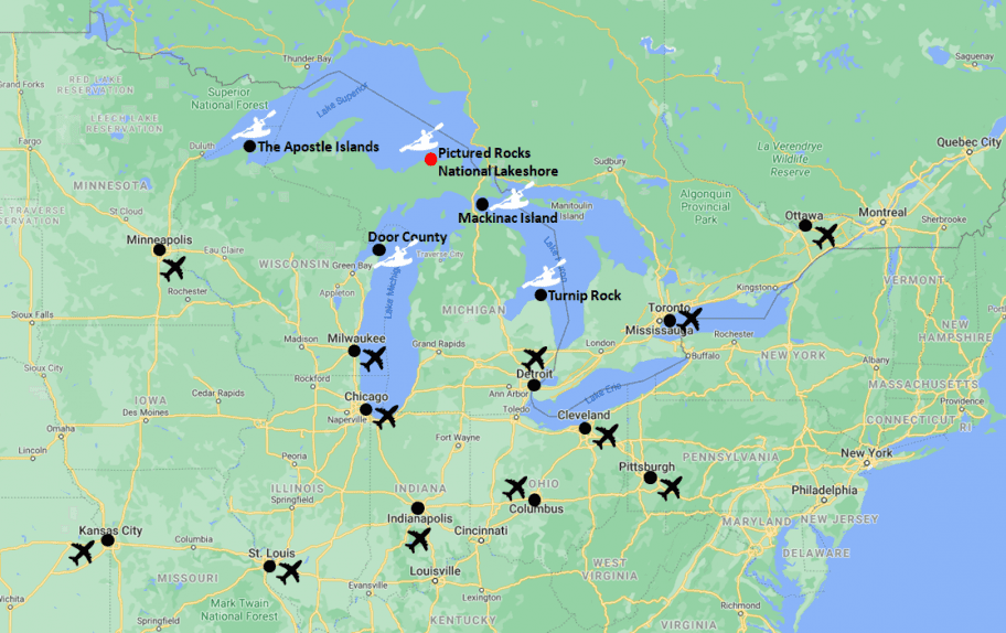
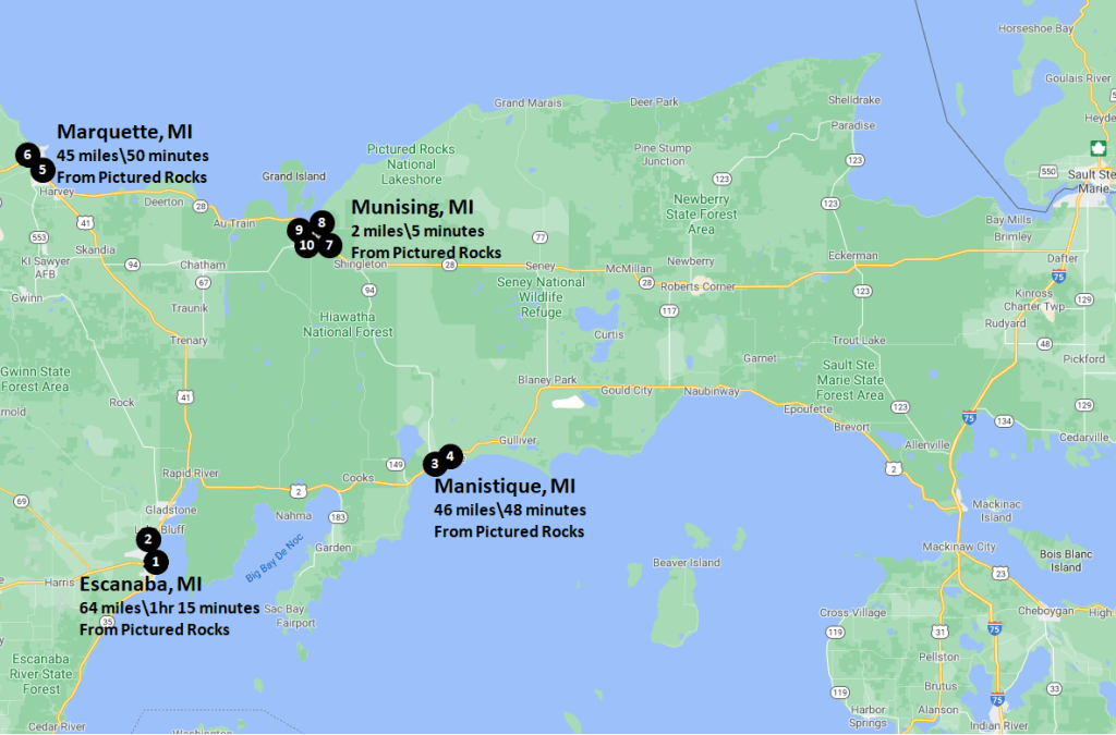
The Pictured Rocks National Lakeshore is located in the Upper Peninsula of the state of Michigan on the southern shore of Lake Superior. If you are planning on visiting the Pictured Rocks National Lakeshore from within the United States, I have included a table below that outlines some of the larger cities in the American Midwest that are within close driving distance of Pictured Rocks to give you an idea of how long it will take you to get there.
If your plans involve staying in the American Great Lakes region for more than a day or two, I have also included the distance to Pictured Rocks from some of the other popular great lakes destinations. There are enough incredible things to see and do in the Upper Peninsula of Michigan and Northern Wisconsin that you could easily spend a long weekend or more in the area and not see everything.
Visiting From Outside the United States
For those who are planning on visiting the American Great Lakes region from outside of the United States, I have included a map below that outlines the large cities in the region with airports. My recommendation would be to fly into either Milwaukee or Chicago and drive up to Pictured Rocks from there as it is a reasonable drive from both cities. Pictured Rocks is also a very reasonable distance from Canadian cities like Ottawa and Toronto, in case you are planning on visiting either of those cities and would like to extend your trip to see Pictured Rocks. If you are looking for camping or hotel accommodations around Pictured Rocks National Lakeshore, please be sure to reference the Where to Stay at Pictured Rocks section in my Pictured Rocks Travel Guide below.
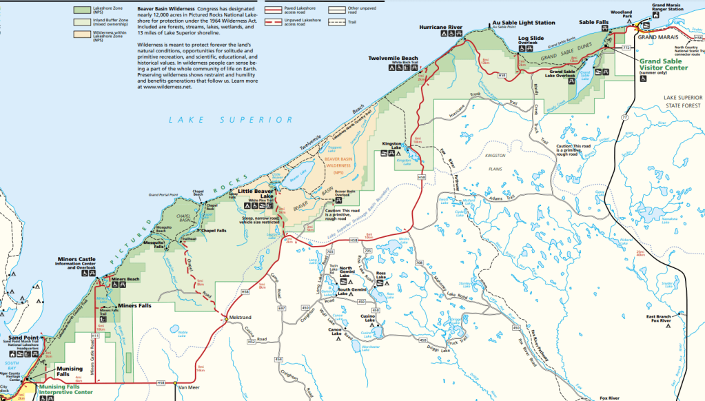
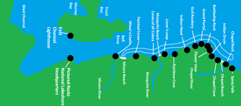
As you can see in the map of the park that I provided in my Pictured Rocks travel guide below, the coastline is quite long. In fact, Pictured Rocks National Coastline stretches over 42-miles from end-to-end. Because of its size, you need to plan your time wisely if you want to see all there is to see when visiting. If you are planning on visiting Pictured Rocks National Lakeshore and would really like to explore the area, I would strongly suggest that you plan on spending at least a full day there. For those travelers who would like to get out on Lake Superior and see the lakeshore from the lake, it is best to plan on spending at least a few full days at Pictured Rocks.
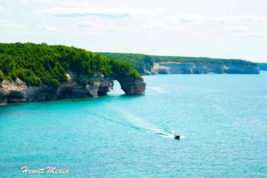
Not only is the Pictured Rocks National Coastline incredibly beautiful, but it is also chalk-full of incredible things to see and do. In addition to being one of the premier kayaking destinations in North America, the Pictured Rocks coastline is also an amazing place to go hiking, climbing, and nature watching. Each year, Pictured Rocks attracts thousands of kayakers, hikers, and outdoor adventure seekers to explore its incredible coastline and hiking trails. If you plan your time wisely when visiting, you can explore the breathtaking rock cliffs at pictured rocks both by boat and by foot. For those who are looking for some fun ideas on what to do while visiting the coastline, I have included a list of my top things to see and do for you to review in my Pictured Rocks Travel Guide below.
Kayak at Pictured Rocks
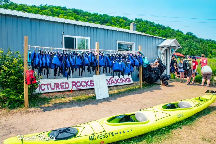
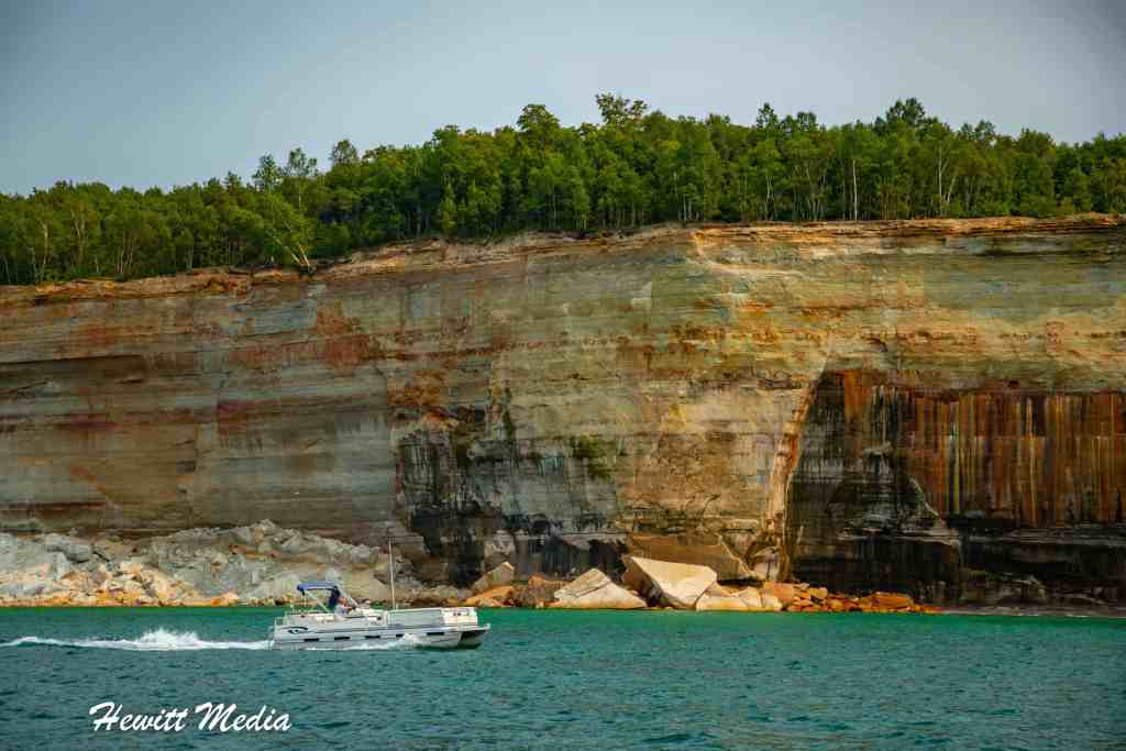
One of the most popular activities for visitors to the Pictured Rocks National Lakeshore to enjoy is kayaking along the breathtaking cliffs and natural rock formations. Believe me, you have no idea just how massive and beautiful the Pictured Rocks coastline is until you are right up against it on the waters of Lake Superior. If you are interested in kayaking when you visit Pictured Rocks, you have the option of bringing your own kayak or booking one of the area's many kayaking tours.
If you would like to learn more about what it is like to kayak at Pictured Rocks National Lakeshore and how to go kayaking during your visit, then I would suggest reading the How to Kayak at Pictured Rocks section of my Pictured Rocks Travel Guide below. In this section of my guide, I review important things like which section of the coastline is best to see, where to launch your kayak if you are bringing your own, and which kayaking tour companies I recommend using.
Take a Pictured Rocks Sightseeing Cruise
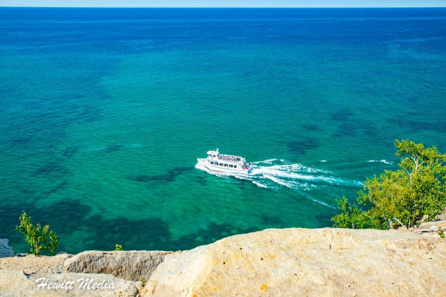
If you would really like to get out onto the waters of Lake Superior to see the beautiful Pictured Rocks coastline, but aren't up for going kayaking, there is another option you should consider. There are a number of tour companies in the Munising, Michigan area that offer boat cruises along the Pictured Rocks National Lakeshore. This is a great way to relax while getting up-close and personal with one of the most beautiful coastlines in North America. If you are interested in booking a boat cruise for your visit to Pictured Rocks, I have included some tour information for you to review below.
Paddling Michigan Boat Tours
The Paddling Michigan tour company offers both lunch and dinner cruises along the Pictured Rocks coastline. The lunch cruises go from 11am-3pm and the dinner cruises run from 5pm-9pm. If you are interested in getting some sunset photographs along the shoreline, the dinner cruise is a great option.
Another great tour company that I recommend using for a boat tour of Pictured Rocks National Lakeshore is Pictured Rocks Cruises. They offer a variety of different tours to meet the needs of all visitors. You can choose between the classic tour, which takes you on a 32-mile round trip voyage along the Pictured Rocks coastline or you can choose to go a little further and visit the legendary Spray Falls as well. In addition to their daytime tours, Pictured Rocks Cruises also offers sunset tours for those who would like to experience the magic of this beautiful coastline at sunset.
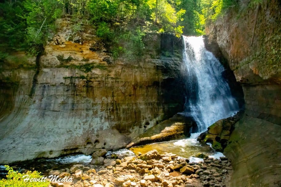
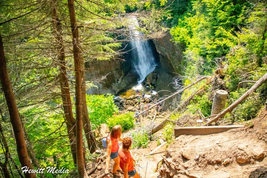
While the breathtaking coastline may steal the show at Pictured Rocks National Lakeshore, the area is also known for its collection of incredible waterfalls. One of the most beautiful of these waterfalls is Miner's Falls, which is located inland from Miner's Beach. If you would like to see Miner's Falls, there is a viewpoint located a short distance off of Miner's Falls Road. It is an easy 1.2-mile round trip hike to the viewpoint that is accessible to hikers of all abilities. Once at the viewpoint, there is a fixed rope that you can use to descend to the foot of the falls (as shown below). It's a steep decent, but the rope makes it rather easy to get down and back up.
Fixed Rope to the foot of Miner's Falls
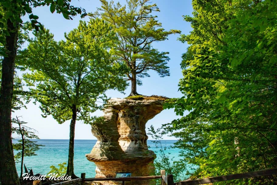
Miner's Castle Viewpoint
A view of Miner's Castle from the Miner's Castle Viewpoint
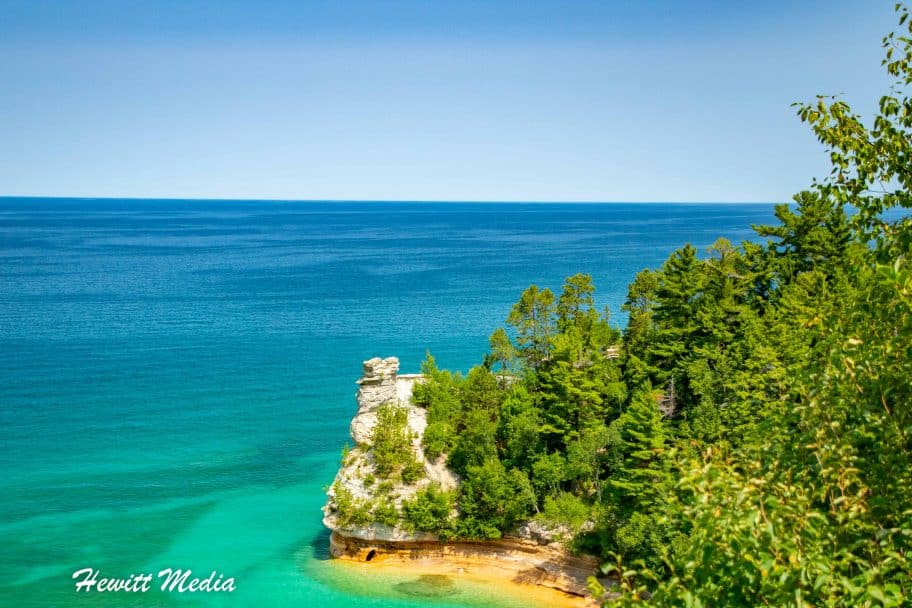
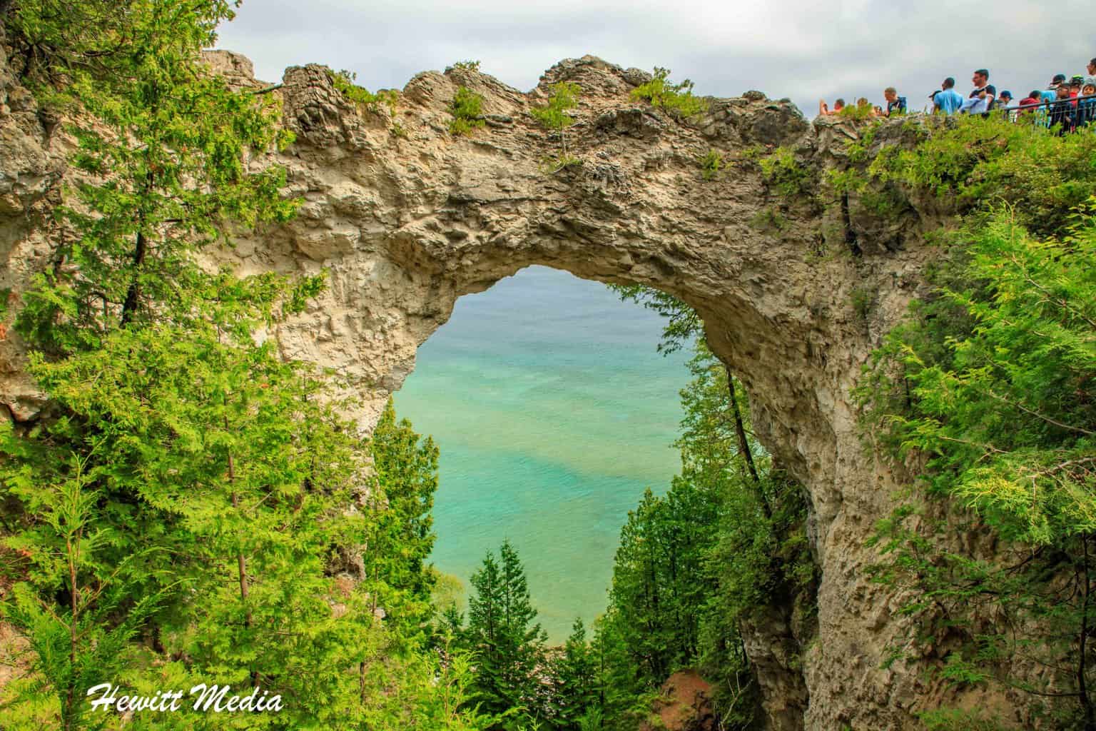
One of the most popular rock features along the Pictured Rocks shoreline is the infamous Miner's Castle. Given it's name by Englishman Alexander Henry's mining employees when they discovered it while looking for minerals in 1771, Miner's Castle is the only section of the most beautiful stretch of the Pictured Rocks National Lakeshore that is accessible by vehicle. There is a large parking lot with an upper and lower viewpoint for viewing Miner's Castle, as well as beach access for those who want to go into the water or launch their kayak.
Hike the Mosquito Falls and Mosquito Beach Loop
A view of Mosquito Beach
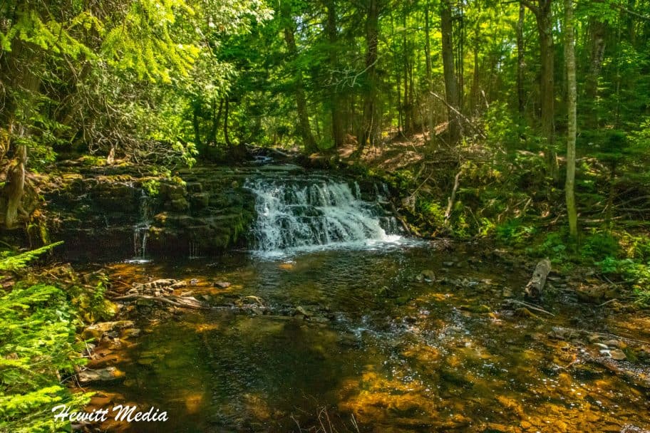
In my opinion, the best section of the Pictured Rocks National Lakeshore for hiking is the Chapel Basin area. Accessible off the main park road via the Chapel Road, this area gives you access to the most beautiful stretch of the Pictured Rocks coastline, as well as several beautiful waterfalls and beaches. One of the popular hikes in this area is the Mosquito Falls (pictured below) and Mosquito Beach (pictured above) loop hike.
A view of Mosquito Falls
Starting Your Hike
This relatively easy loop hike will take you from the Chapel Basin area parking lot down to the coastline of Lake Superior. On your way, you will get to see the beautiful Mosquito Falls. If you would like to just hike to the falls and back, it is an easy 2-mile out-and-back hike from the parking lot. If you continue on from the falls, it's roughly a 1.6-mile hike from Mosquito Falls down to Mosquito Beach on the Pictured Rocks coastline.
Looping Back to the Parking Area
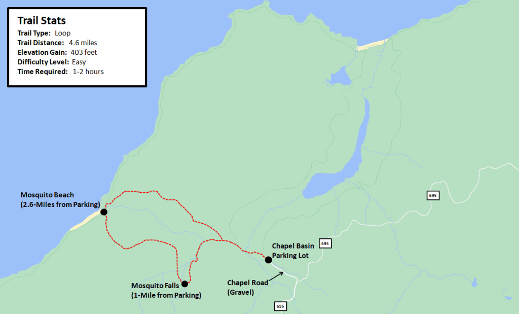
At the beach, you will see kayakers who have pulled out to rest and enjoy some time on the beach, as well as campers who are camped out near Mosquito Beach enjoying some beach time. If you have the time, you might want to consider enjoying some time at the beach before making the 2-mile hike back to the parking lot. For those interested in this hike, I have included a map of the Mosquito Falls and Mosquito Beach Loop Hike in my Pictured Rocks Travel Guide for you to review below.
Expert Tips for Mosquito Falls and Mosquito Beach Loop Hike
When visiting the Chapel Basin area, be aware that the Chapel Road is a gravel road. If the weather has been wet, the road can sometimes have large puddles and be challenging to navigate. The parking area also fills up very early in the day when the weather is nice, so I would plan on arriving early if you want to hike in the area.
Map of the Mosquito Falls and Mosquito Beach Loop Hike
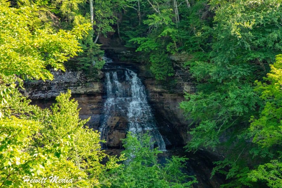
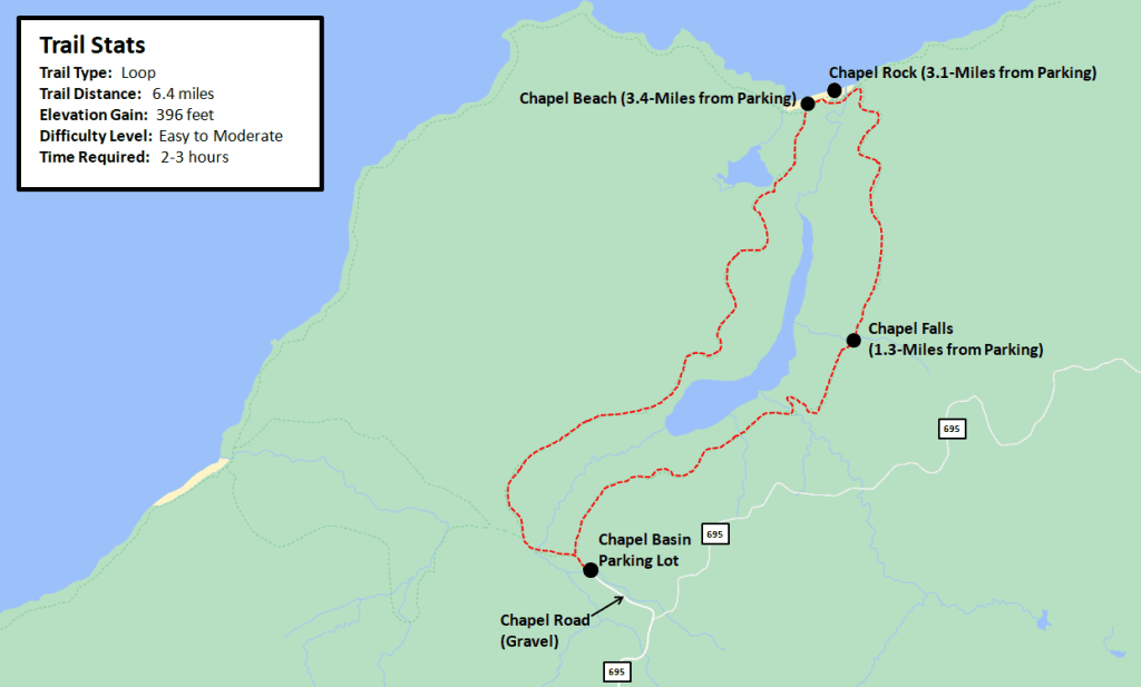
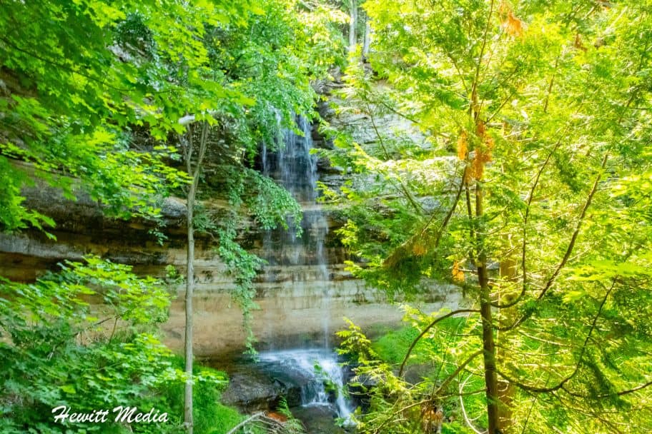
Another incredible hike that is available in the Chapel Basin area of Pictured Rocks National Lakeshore is the Chapel Rock (pictured above) and Chapel Falls (pictured below) Loop hike. Although it is a little longer than the Mosquito Falls and Mosquito Beach loop, it is still rather easy and accessible to hikers of most skill levels.
A view of Chapel Falls
Starting Your Hike
The hike takes you from the Chapel Basin parking area down to the Lake Superior shoreline near Chapel Beach. On your way down to the beach, you will pass the beautiful Chapel Falls. There is a lookout deck where you can get some amazing views of the falls and take some great pictures (as shown above). For hikers who are only interested in seeing the falls, it is a roughly 2.6-mile out-and-back hike from the parking area.
From the Chapel Falls viewing area, it is roughly another 1.8-miles to Chapel Rock, which is an incredible rock formation that sits on the Pictured Rocks coastline. This amazing rock formation used to be a natural arch, but the archway has since fallen into the lake. All that remains now is a large root structure that stretches in mid-air to the coastline to provide nutrients to the trees on top of Chapel Rock.
Looping Back to the Parking Area
Roughly a quarter mile passed Chapel Rock you will find the Chapel Beach and the Chapel Beach camping area. Like Mosquito Beach, the Chapel Beach will likely have plenty of swimmers, kayakers, and campers enjoying the water and the weather. If you have the time, I would suggest taking a break on the beach before completing the roughly 3-mile hike back to the parking area. For those interested in this hike, I have included a map of the Chapel Falls and Chapel Rock Loop Hike in my Pictured Rocks Travel Guide for you to review below.
Expert Tips for Chapel Rock and Chapel Beach Loop Hike
When visiting the Chapel Basin area, be aware that the Chapel Road is a gravel road. If the weather has been wet, the road can sometimes have large puddles and be challenging to navigate. The parking area also fills up very early in the day when the weather is nice, so I would plan on arriving early if you want to hike in the area. Also, DO NOT under any circumstance try and use the root structure to get on top of Chapel Rock. It is the only thing keeping the trees alive and you will get a BIG fine if you are caught.
A view of the Pictured Rocks coastline on the Mosquito Falls and Chapel Falls Loop Hike
For hikers who are up for a challenge and would like to see the best that the Pictured Rocks coastline has to offer, I would recommend my favorite hike in the Pictured Rocks National Lakeshore area. The Mosquito Falls and Chapel Falls loop hike combines portions of the Mosquito Falls and Chapel Falls loop hikes with a roughly 4-mile hike along the lakeshore. It's a very long hike, so I would definitely recommend that you have the time and are comfortable with the 10+ mile distance before attempting this hike.
Starting the Hike
This is a loop hike, so the trail both begins and ends at the Chapel Basin Area parking lot. From there, you can either hike passed Mosquito Falls to Mosquito Beach or passed Chapel Falls to Chapel Rock. Regardless of which direction you hike, once you reach the coastline you will follow the Lakeshore North Country Trail along Lake Superior for roughly 4-miles.
The Lakeshore North Country Trail
As you hike along the Lakeshore trail, you will get to see the absolute best of the Pictured Rocks National Lakeshore coastline. The most beautiful section of the Pictured Rocks coast stretches from Mosquito Beach to Chapel Rock, which is exactly where this loop hike takes you. If you are curious about what you will see as you hike along the Lakeshore trail, I have included a map and some pictures for you to review in my Pictured Rocks Travel Guide below.
Finishing the Hike
Because it is a loop hike, you will finish on the other side of the Pictured Rocks coastline from where you began your hike. If you started your hike by hiking passed Mosquito Falls to Mosquito Beach, you will finish your hike by hiking up passed Chapel Falls from Chapel Rock to the Chapel Basin Area parking lot. Vice versa, if you began your hike by hiking passed Chapel Falls to Chapel Rock, you will finish your hike by hiking passed Mosquito Falls from Mosquito Beach to the Chapel Basin parking area.
Expert Tips for Mosquito Falls and Chapel Falls Loop Hike
When visiting the Chapel Basin area, be aware that the Chapel Road is a gravel road. If the weather has been wet, the road can sometimes have large puddles and be challenging to navigate. The parking area also fills up very early in the day when the weather is nice, so I would plan on arriving early if you want to hike in the area.
Map of the Mosquito Falls and Chapel Falls Loop Hike
In addition to its incredible coastline and amazing waterfalls, another aspect of Pictured Rocks National Shoreline that draws thousands of visitors to the area each year are the great beaches. One of the most popular beaches along the Pictured Rocks shoreline is located at what is called Sand Point. Situated just outside of the city of Munising near the Munising Visitor Center, the Sand Point Beach is a large beach with soft sand and calm waters (on nice days). If you are visiting Pictured Rocks with children, it is a great spot to stop for a while and enjoy the sun and let the kids play in the water.
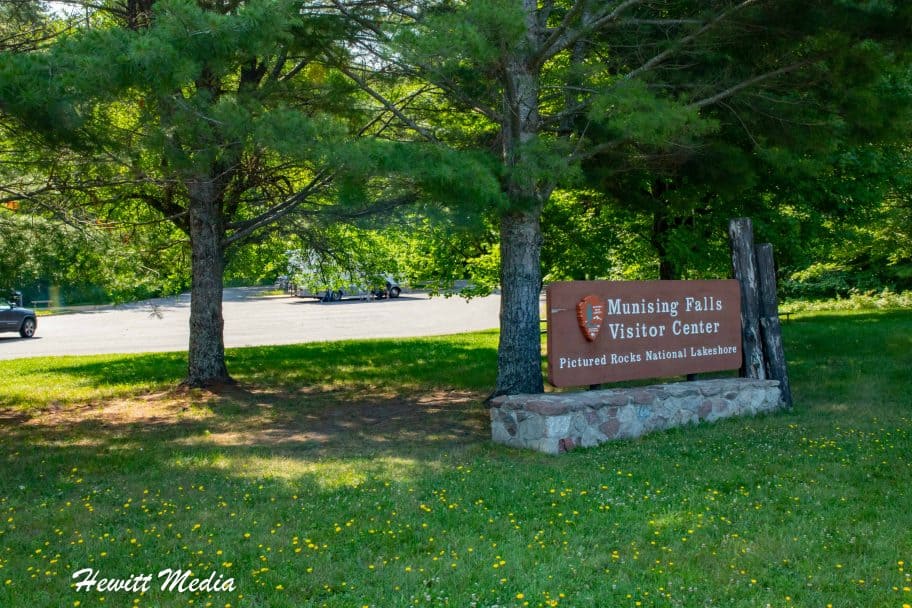
Munising Falls
A view of Munising Falls
Of all the waterfalls located in the Pictured Rocks National Lakeshore area, the most readily accessible is without a doubt the Munising Falls. Located a very short distance beyond the Munising Visitor Center, the Munising Falls requires very little effort to see, which makes it a very popular spot for all tourists visiting the shoreline. It's a beautiful waterfall that can be viewed from several different observation areas, so getting some great shots of this waterfall is easy to do.
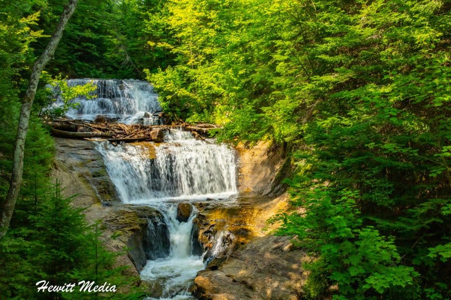
Sable Falls
A view of Sable Falls
While most of the attractions on my list of the top things to see and do at Pictured Rocks National Lakeshore are located near the Munising side of the shoreline, there is one spot near the Grand Marais end that I consider to be a must-see spot. Of all the waterfalls inside the Pictured Rocks National Lakeshore, my favorite is the breathtaking Sable Falls. This tiered waterfall is absolutely beautiful when you see it in person, so it makes the 30+ minute drive up to the northern end of the shoreline well worth the effort. There is a deck walkway with stairs that take you to several different observation points in which to view the falls, so you will get to see its beauty from multiple perspectives when you visit.
How to Kayak at Pictured Rocks
Let's face it, most people who visit Pictured Rocks National Lakeshore come to see the incredibly beautiful rock cliffs that make the coastline famous. While there are other ways to see and explore these rock cliffs, one of the most popular ways for travel adventurists to get up-close-and-personal with the Pictured Rocks is to get out on the water in a kayak. If you are interested in doing some kayaking while visiting Pictured Rocks, I have included some advice on the different ways in which you can do so in my Pictured Rocks Travel Guide below.
What It's Like to Kayak at Pictured Rocks
There are many incredible places that you can go kayaking in the American Great Lakes region, and each of these destinations is unique in its own way. For instance, kayaking in the waters around Mackinac Island in Lake Michigan or in the Door County region of Wisconsin is a lot more low-key than in other areas of the Great Lakes. On the other hand, destinations like Turnip Rock in Lake Huron near Port Austin, Michigan has become a kayaking hot spot and attracts big crowds of kayakers during the summer months. Other destinations, like the Apostle Islands in the waters of Lake Superior in Northern Wisconsin are a mixture of the two. While the crowds aren't as big, the kayaking certainly is adventurous.
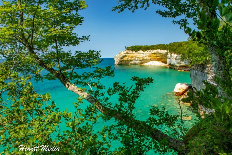
Out of all the places that I have gone kayaking in the American Great Lakes, I would say that Pictured Rocks National Lakeshore is both the most awe-inspiring and the most crowded. With a number of great tour companies that offer daily tours of the Pictured Rocks by kayak and the ability to drop kayakers in the water right by the cliffs, it has become easier than ever for just about anyone to experience the wonders of Pictured Rocks from the water. Even though the experience has gone mainstream in recent years, the experience itself remains as magical as ever. You really have no idea how tall and jaw-droppingly beautiful the Pictured Rocks cliffs are until you are right next to them in the water.
Best Places to Kayak at Pictured Rocks
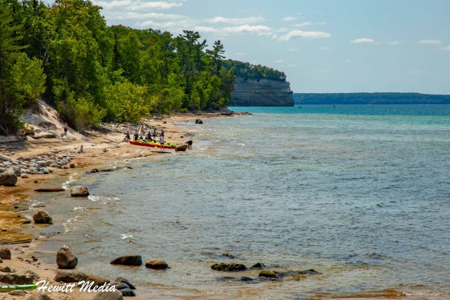
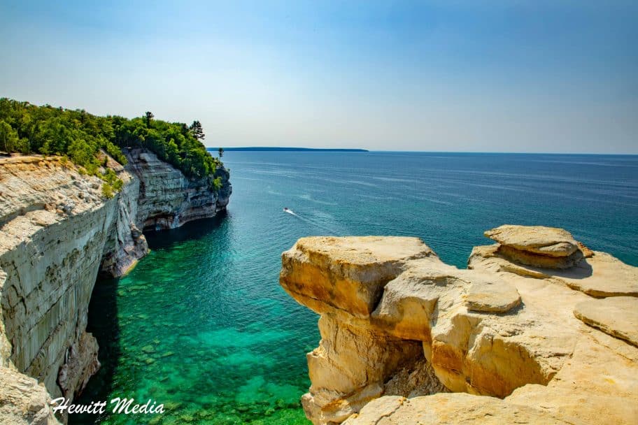
As I mentioned before, the Pictured Rocks National Lakeshore is a very large area. It would take you multiple days to kayak the entire 42-mile stretch, and that is only one way. If you would like to kayak at Pictured Rocks, the first thing that you need to know is which areas of the coastline are the best to see. If you take a look at the map that I included in my Pictured Rocks Travel Guide below, you will notice that the most beautiful section of pictured cliffs at Pictured Rocks is located between Miner's Castle and Chapel Rock.
This roughly 6-miles of coastline includes some of the most beautiful cliffs, natural archways, and rock formations that you will find along the entire Pictured Rocks National Lakeshore. This is the area of the coastline that all of the Pictured Rocks kayaking tours take you and it is the area of the coastline I would focus on if you are going to kayak Pictured Rocks on your own.
One of the easiest ways to explore the Pictured Rocks National Lakeshore by kayak is to take a kayaking tour thru one of the many reputable tour companies in the area. Depending on your comfort level in a kayak and the time that you want to spend on the water, there are a variety of tours that you can choose from. Two of the top kayaking tour companies that operate at Pictured Rocks National Lakeshore are Pictured Rocks Kayaking and Paddling Michigan. While both tour companies offer kayaking tours of Pictured Rocks, their tours are a bit different. To help you choose the best tour company for your needs, I have included some details on each companies tours in my Pictured Rocks Travel Guide below for you to review.
Pictured Rocks Kayaking Tours
What sets the tours that Pictured Rocks Kayaking offers a part from tours offered by other companies operating at Pictured Rocks is that they use two large boats to transport you and the kayaks to the Pictured Rocks coastline. This means that there are no long paddles or hikes required to get to the beautiful stretch of coastline. It also means that there is a support boat by you the entire time in case you need to get out of the water for some reason.
This makes kayaking tours with Pictured Rocks Kayaking great for novice kayakers who want to experience kayaking at Pictured Rocks, but aren't confident that they would be able to kayak the 11-plus miles that other tours required. On the flip side, Pictured Rocks Kayaking doesn't offer the variety of tours that other tour companies offer and their tours tend to be shorter than other tour companies.
If you are looking a little more adventurous kayaking trip at Pictured Rocks National Lakeshore, then the tour company that I would recommend booking with would be Paddling Michigan. They offer a wider variety of kayaking tours to the Pictured Rocks coastline, including some longer trips and some kayaking\hiking combo tours. These tours will be far more challenging for experienced kayakers who are looking for a little more adventure.
In addition to their lengthier tours, Paddling Michigan does offer some shorter tours for less experienced kayakers. However, you don't get to see as much of the Pictured Rocks coastline on these shorter tours as you do on the Pictured Rocks Kayaking tours. For that reason, I would recommend booking with Pictured Rocks Kayaking if you are looking for a shorter tour of the Pictured Rocks coastline.
If you own your own kayaks and are not interested in taking a kayaking tour at Pictured Rocks National Lakeshore, the other option that you have is to go kayaking on your own. However, before you commit to kayaking on your own at Pictured Rocks, there are some things that you should be aware of and keep in mind before making that decision:
The best place to launch your kayak if you are going to kayak at Pictured Rocks National Lakeshore on your own would be at Miner's Castle Beach. The Miner's Castle lookout includes a large parking lot and a beach where you can safely launch your kayak and get it out of the water when you are finished.
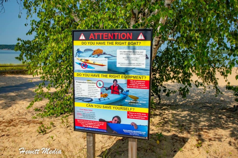
The waters of Lake Superior can be very unpredictable and treacherous. Make sure to always check the weather forecast before getting out on the water in a kayak and know where you can safely take your kayak out of the water along the coastline should the weather turn bad. There aren't any good pull-out spots between Mosquito Beach and Chapel Beach, so avoid getting stuck in between during bad weather.
Don't attempt to kayak at Pictured Rocks National Lakeshore on your own if you are incapable or uncomfortable with performing the self-rescue and safety steps outlined by the Park Authority (as shown below).
Pictured Rocks National Lakeshore Safety and Self-Rescue Guidance
When to Visit Pictured Rocks
Because of its location in the Upper Peninsula of Michigan, the Pictured Rocks National Lakeshore can get quite cold during the winter months and see quite a bit of snowfall. During these winter months, most of the park roads are not plowed and large stretches of the coastline become inaccessible by car. For these reasons, most of the visitors who come to Pictured Rocks National Lakeshore do so during the late spring, summer, and early autumn months. However, there are still some adventurous souls who come to the park during the winter to snowshoe, cross-country ski, and climb the coastline's frozen waterfalls. If you plan on visiting Pictured Rocks during the winter to go snow shoeing, I would recommend reading my Snowshoe Gear Guide for Adventure Travelers linked below.
Because of its northern location, the Pictured Rocks National Lakeshore gets very cold during the winter months of December thru February. If you are planning on visiting the park during these months, then I would strongly recommend bringing warm weather gear with you. The Pictured Rocks coastline is a popular cross-country skiing and snowshoeing area during the winter, so there are activities to enjoy in the park during the winter months. However, the Pictured Rocks coastline tends to attract many more visitors during the summer months when the Pictured Rocks coastline is accessible via hiking trails and boats. For those travelers who are looking to get out on the water, but would like to beat the crowds, I would recommend targeting the late spring months of April and May or the early autumn months of September and October.
Average Precipitation (Inches)
If you are visiting the Pictured Rocks National Lakeshore to do some hiking or kayaking, you are going to want to have nice whether when you visit. Few things are more dangerous than being out on Lake Superior during bad weather in a small vessel. The waters of Lake Superior can be cold enough to send you into hypothermia in just a few minutes. For that reason, I would suggest that you plan your trip to Pictured Rocks when the weather has the best chance of being nice. That means avoiding the autumn months if you want to get out on the water.
Average Visitors (Visitors Per Day)
Because of the popularity of its summertime activates, it should come as no surprise to anyone that the summer months are the busiest months at the Pictured Rocks National Lakeshore. If you don't like crowded trails and crowded waters, then I would avoid visiting during the months of July and August. Instead, I would target the months of May or June if you want to visit to go kayaking, or September if you are visiting to hike. These shoulder months tend to have nice weather, but far smaller crowds than during the summer.
What to Pack for Pictured Rocks
When visiting the Pictured Rocks National Lakeshore, it is imperative that you be prepared. This is especially true if you plan on getting out on the waters of Lake Superior to go kayaking, canoeing, or swimming. In order to make sure that you have the proper gear with you to safely hike, kayak, and explore this beautiful stretch of coastline, I have included a link to my Essential Pictured Rocks Packing Guide for you to review below.
In addition to all of the amazing things to see and do along the Pictured Rocks National Lakeshore, the American Great Lakes region has some other amazing stretches of coastline and attractions that I think outdoor travel enthusiasts would really love to explore. If you are looking for some additional destinations in the area to add to your travel itinerary, I have included some recommendations in my Pictured Rocks Travel Guide for you to review below.
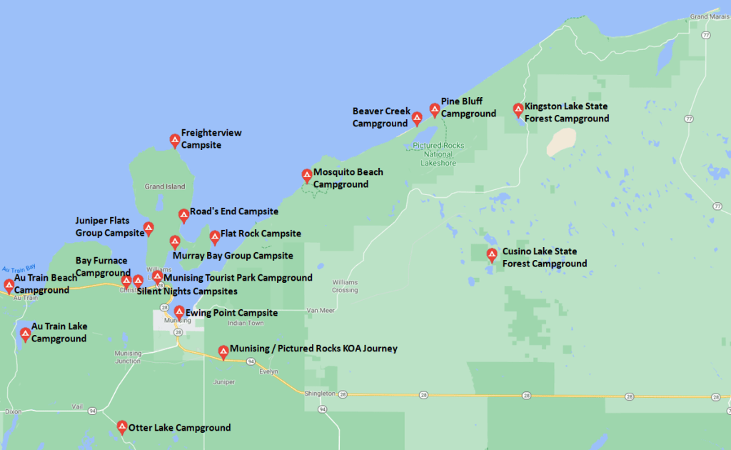
When visiting the national parks, monuments, and lakeshores of the United States, it is a really neat experience to camp out during your visit. Some of the best campgrounds in America can be found inside the country's national parklands and the surrounding areas. If you are interested in camping out during your visit, I have included a map and list of some recommended campgrounds for you to review in my Pictured Rocks National Lakeshore Travel Guide below.
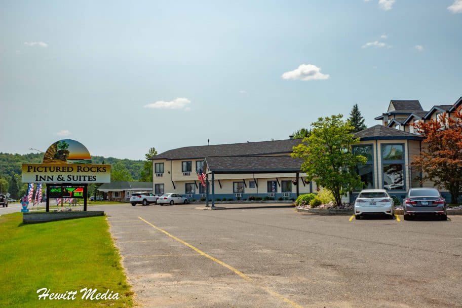
If camping is not your speed, you need not worry as there are a variety of good hotels for you to choose from in the Upper Peninsula of Michigan as well. If you are in the process of planning your trip to the Pictured Rocks National Lakeshore and are looking for recommendations on hotels in the area, I have included a map and list of recommended hotels at different price points for you to review in my Pictured Rocks Travel Guide below.
When planning any trip, you can never have too many resources at your disposal. In addition to the information I have provided you in this guide, I have linked to a number of other official resources from the US National Parks Service in my Pictured Rocks National Lakeshore travel guide below for you to use to plan your trip as well.
The Pictured Rocks National Lakeshore is a beautiful place and there are plenty of great things to see and do along the coastline. However, it isn't the only amazing thing to see in the American Great Lakes region. If you are going to be in the area for a few days and are looking for some activities to add to your agenda, I have included links to some of the more popular tours and excursions in the area for you to review below.
During my many visits to the Pictured Rocks National Lakeshore, I have been able to capture a lot of amazing photographs of this beautiful stretch of coastline. If you are interested in seeing some of my top pictures, I have included a gallery of images in my Pictured Rocks Travel Guide for you to review below.
[WRGF id=24188]
Get My Ultimate Travel Guide
Sign-up to receive the latest updates from my travel blog and start receiving premium content that you will not find on this blog, starting with my Ultimate Travel Guide. This comprehensive guide outlines the process that I use to book all of my trips and includes tips and tricks for streamlining the travel planning process and saving you money on travel.


No comments:
Post a Comment